Africa In Perspective: It's big. Really big.

cancel2 2022

Canceled
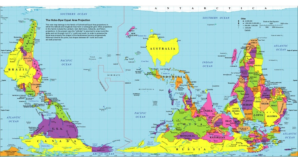
It is interesting to see just how big Africa is in relation to other parts of the world.

africa-in-perspective.jpg


http://www.doobybrain.com/2008/06/01/africa-in-perspective-its-big-really-big/
 
I was under the impression that Africa was small.

did you know that because of the chosen perspective world maps overemphasize the geographical scale of the continents in the Northern Hemisphere?....when the spread out the triangles of the latitude markers they simply fill in the space that was created with more land.....here's a map that eliminates that misrepresentation....
SouthUpMapr.jpg
 
I was under the impression that Africa was small.

I have a friend that drove a Land Rover in the mid '70s from the top of Africa to the bottom with several others. At one stage they ended up going through Angola, right in the middle of a civil war. They then crossed into Namibia and ended up in detention in South Africa for a few days as the police thought they were spies.
 
Last edited:
did you know that because of the chosen perspective world maps overemphasize the geographical scale of the continents in the Northern Hemisphere?....when the spread out the triangles of the latitude markers they simply fill in the space that was created with more land.....here's a map that eliminates that misrepresentation....

Yes, it's a well known problem with the overused mercator projection (which is really only supposed to be used in navigation - it has certain properties that are useful in that field). And equal-area projections such as Hobo-Dryer can correct for that. Another one is the Peters' projection, but the internet hates it.

Mercator makes Greenland look as big as Africa:

Worldmer.gif


When in reality it's just a little sliver:

250px-Greenland_(orthographic_projection).svg.png


But I've known that since I was a child. And, of course, Hobo-dryer gets the actual shape entirely wrong, just the size right. It's, of course, impossible to get the shape and area entirely right on a square map.
 
I have a friend that drove a Land Rover in the mid '70s from the top of Africa to the bottom with several others. At one stage they ended up going through Angola, right in the middle of a civil war. They then crossed Namibia and ended up in detention in South Africa for a few days as the police thought they were spies.

Note to self: when planning a road trip, make sure that I avoid countries in the middle of a war of independence from white people. Especially without any visa, permission to do so, or proof that I'm anything but a spy/person working for the Portuguese.
 
Back
Top